
Seawater intrusion in the Salinas Valley has been studied since the 1940s. This page contains a library of reports and related materials on seawater intrusion from several agencies and sources.
- 1946 Salinas Basin Investigation Summary Report
- 1976 Hydrogeological Report on the Deep Aquifer
- 1976 Report on Castroville Irrigation Project Part 1
- 1976 Report on Castroville Irrigation Project Part 2
- 1988 Simulated Effects of Ground-Water Management Alternatives for the Salinas Valley
- 2001 Final Report: Hydrogeologic Investigation of the Salinas Valley Basin
- 2002 Geohydrology Deep Aquifer Monitoring
- 2003 Technical Memorandum: Deep Aquifer Investigation
- 2004 Hydrostratigraphic Analysis of the Northern Salinas Valley
- 2005 Final Report: Installation of Deep Aquifer Monitoring Wells
- 2007 El Toro Groundwater Study
- 2017 MCWRA Recommendations to Address Expansion of Seawater Intrusion
- 2017 Salinas Valley Groundwater Level Contours & Seawater Intrusion Maps
- 2018 Deep Aquifers Roundtable Meeting
- 2019 North Monterey County Crought Contingency Plan
- 2019 Integrated Coastal Groundwater Monitoring Program and Plan
- 2020 Update: MCWRA Recommendations to Address Expansion of Seawater Intrusion
- Mapping Aquifer Systems with Airborne Electromagnetics in the Central Valley of California
- Using an Airborne Electromagnetic Method to Map Saltwater Intrusion in the Northern Salinas Valley, California
- Electrical Resistivity Imaging Seawater Intrusion into the Monterey Bay Aquifer
- Calibrating a Saltwater Intrusion Model with Time-Domain Electromagnetic Data
- Interpretation of Hydrostratigraphy and Water Quality from AEM Data Collected in the Northern Salinas Valley, CA
- Mapping Saltwater Intrusion With an Airborne Electromagnetic Method in the Offshore Coastal Environment, Monterey Bay, California
- 2020 Independent Evaluation, Modification, and Use of the North Marina Groundwater Model to Estimate Potential Aquifer Impacts
- 2018 Greater Monterey County Integrated Regional Water Management Plan
- Monterey Peninsula Water Management District Total Water Management: Evaluating Options for a Reliable Water Future
- Well Completion Reports
- 2017 Hydrologic Working Group Hydrogeologic Investigation
- 2019 Weiss Review of Recent Data and Studies
- 2018 HWG Response to Legal Brief Tech
- 2019 Marina Permit HWG Response
- 2019 Exhibit 14 HWG AEM Response
- AGF-MCWD 2019 Final AEM Report
- 2018 FO Sampling Data Transmittal
- 2019 MCWD AEM Study Supplemental Information
- Stanford AEM Method to Map Seawater Intrusion Geophysics
- 2017 Stanford AGF AEM Study Report Final
- Appendix 1 – 2D Profiles 2019 Rho-Elogs Comparison
- Appendix 1 – 2D Profiles 2017 2019 Rho Comparison with Lith Logs
- Appendix 1 – 2D Profiles 2019 Rho-CLconc Lith-Elogs Comparison
- Appendix 1 – 3D Fence Diagram
- Appendix 1 – 2D Profiles 2019 2019 CLconc Comparison with Logs
- Appendix 2 – 3D Fence Diagram MCWD 2019 Rho
- Appendix 2 – 3D Fence Diagram MCWD 2019 CLconc
- Appendix 2 – 3D Voxels – Comparison 2017-2019 VoxelBelowRho75 for Ranges 1-500 and 10000-40000
- Appendix 2 – 3D Voxel Depth Slices – Comparison 2017-2019 CL Concentrations
- Appendix 2 – 3D Voxel Easting Slices – Comparison 2017-2019 CL Concentrations
- Appendix 2 – 3D Voxel Northing Slices – Comparison 2017-2019 CL Concentrations
- Geosciences Support Services Reports for Cal-Am Project
- 2014 GSSI Exploratory Boreholds (TM1)
- 2014 GSSI Slant Well Predictive Scenarios
- 2015 GSSI MPWSP Groundwater Modeling and Analysis
- 2017 GSSI Monitoring Well Completion Report (TM2)
- SWIG Meeting 2/28/22 Salinas Valley Seawater Intrusion Model
- SWIG Meeting 1/24/22 PowerPoint
- SWIG Meeting 1/24/22 Deep Aquifers Study PowerPoint
- SWIG Meeting 1/24/22 SGMA Grant PowerPoint
- SWIG Meeting 11/22/21 PowerPoint
- SWIG Meeting 11/22/21 United Water Conservation District PowerPoint
- SWIG Meeting 10/25/21 Winter Release PowerPoint
- SWIG Meeting 10/25/21 PowerPoint
- SWIG Meeting 9/27/21 PowerPoint
- SWIG Meeting 9/27/21 Extraction Barrier PowerPoint
- SWIG Meeting 8/2/21 PowerPoint
- SWIG Meeting 6/28/21 Powerpoint
- SWIG Meeting 6/28/21 TAC Survey Results and Discussion
- SWIG Meeting 6/28/21 Drought Presentation Slides
- SWIG Meeting 4/26/21 SWI Model Capabilities
- SWIG Meeting 3/22/21 Powerpoint
- SWIG Meeting 2/22/21 Powerpoint
- SWIG Meeting 1/25/21 Powerpoint
- SWIG Meeting 11/23/20 Powerpoint
- SWIG Meeting 11/23/20 TAC Deep Aquifer Study Recommendations
- SWIG Meeting 10/26/20 Powerpoint
- SWIG Meeting 9/28/20 Powerpoint
- SWIG Meeting 8/24/20 Powerpoint
- SWIG Meeting 7/27/20 Powerpoint
- SWIG Meeting 6/19/20 #1 Powerpoint
- SWIG Meeting 6/19/20 #1a Powerpoint
- SWIG Meeting 6/19/20 #1b Powerpoint
- SWIG Meeting 6/19/20 #1c Powerpoint
Maps
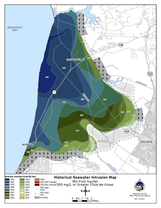
p180_2022_SWI
Pressure 180-Foot Aquifer
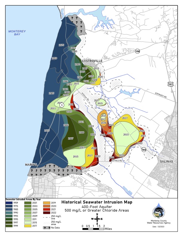
p400_2022_SWI
Pressure 400-Foot Aquifer
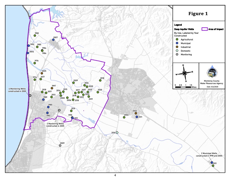
DeepWells_map
Deep Wells Map
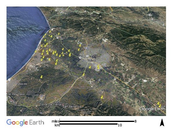
DeepAquifers_WellsMap_August2020
Deep Aquifer Wells
(.kml file which requires an Earth browser such as Google Earth to open)