
Seawater intrusion in the Salinas Valley has been studied since the 1940s. This page contains a library of reports and related materials on seawater intrusion from several agencies and sources.
- 1946 Salinas Basin Investigation Summary Report
- 1976 Hydrogeological Report on the Deep Aquifer
- 1976 Report on Castroville Irrigation Project Part 1
- 1976 Report on Castroville Irrigation Project Part 2
- 1988 Simulated Effects of Ground-Water Management Alternatives for the Salinas Valley
- 2001 Final Report: Hydrogeologic Investigation of the Salinas Valley Basin
- 2002 Geohydrology Deep Aquifer Monitoring
- 2003 Technical Memorandum: Deep Aquifer Investigation
- 2004 Hydrostratigraphic Analysis of the Northern Salinas Valley
- 2005 Final Report: Installation of Deep Aquifer Monitoring Wells
- 2007 El Toro Groundwater Study
- 2017 MCWRA Recommendations to Address Expansion of Seawater Intrusion
- 2017 Salinas Valley Groundwater Level Contours & Seawater Intrusion Maps
- 2018 Deep Aquifers Roundtable Meeting
- 2019 North Monterey County Crought Contingency Plan
- 2019 Integrated Coastal Groundwater Monitoring Program and Plan
- 2020 Update: MCWRA Recommendations to Address Expansion of Seawater Intrusion
- Mapping Aquifer Systems with Airborne Electromagnetics in the Central Valley of California
- Using an Airborne Electromagnetic Method to Map Saltwater Intrusion in the Northern Salinas Valley, California
- Electrical Resistivity Imaging Seawater Intrusion into the Monterey Bay Aquifer
- Calibrating a Saltwater Intrusion Model with Time-Domain Electromagnetic Data
- Interpretation of Hydrostratigraphy and Water Quality from AEM Data Collected in the Northern Salinas Valley, CA
- Mapping Saltwater Intrusion With an Airborne Electromagnetic Method in the Offshore Coastal Environment, Monterey Bay, California
- SWIG Meeting 2/28/22 Salinas Valley Seawater Intrusion Model
- SWIG Meeting 1/24/22 PowerPoint
- SWIG Meeting 1/24/22 Deep Aquifers Study PowerPoint
- SWIG Meeting 1/24/22 SGMA Grant PowerPoint
- SWIG Meeting 11/22/21 PowerPoint
- SWIG Meeting 11/22/21 United Water Conservation District PowerPoint
- SWIG Meeting 10/25/21 Winter Release PowerPoint
- SWIG Meeting 10/25/21 PowerPoint
- SWIG Meeting 9/27/21 PowerPoint
- SWIG Meeting 9/27/21 Extraction Barrier PowerPoint
- SWIG Meeting 8/2/21 PowerPoint
- SWIG Meeting 6/28/21 Powerpoint
- SWIG Meeting 6/28/21 TAC Survey Results and Discussion
- SWIG Meeting 6/28/21 Drought Presentation Slides
- SWIG Meeting 4/26/21 SWI Model Capabilities
- SWIG Meeting 3/22/21 Powerpoint
- SWIG Meeting 2/22/21 Powerpoint
- SWIG Meeting 1/25/21 Powerpoint
- SWIG Meeting 11/23/20 Powerpoint
- SWIG Meeting 11/23/20 TAC Deep Aquifer Study Recommendations
- SWIG Meeting 10/26/20 Powerpoint
- SWIG Meeting 9/28/20 Powerpoint
- SWIG Meeting 8/24/20 Powerpoint
- SWIG Meeting 7/27/20 Powerpoint
- SWIG Meeting 6/19/20 #1 Powerpoint
- SWIG Meeting 6/19/20 #1a Powerpoint
- SWIG Meeting 6/19/20 #1b Powerpoint
- SWIG Meeting 6/19/20 #1c Powerpoint
- Salinity Barriers to Manage Saltwater Intrusion in Coastal Zone Aquifers During Global Climate Change: A Review and New Perspective
Thomas M. Missimer 1,* and Robert G. Maliva 2 - Management of Seawater Intrusion in Coastal Aquifers: A Review
Mohammed S. Hussain, Hany F. Abd-Elhamid, Akbar A. Javadi, and Mohsen M. Sherif - Seawater intrusion and coastal groundwater resources management. Examples from two Mediterranean regions: Catalonia and Sardinia
Josep Mas-Pla, Giorgio Ghiglieri, Gabriele Uras - 60 Years of Controlling Seawater Intrusion in Orange County, California
Bill Leever Roy Herndon - State-of-the-art on the conceptual advancement of seawater intrusion: A comprehensive review, management, and possible future research direction
Mohammed Benaafi a, S.I. Abba a,⇑, Isam H. Aljundi - Tapping Into Torrance’s Brackish Water Plume
L.L. Poirier - Dynamics of negative hydraulic barriers to prevent seawater intrusion
M. Pool - Preventing Seawater Intrusion and Enhancing Safe Extraction Using Finite-Length, Impermeable Subsurface Barriers: 3D Analysis
Huiqiang Wu, Chunhui Lu, Jun Kong, Adrian D. Werner
Maps
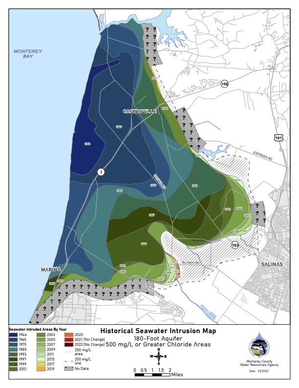
p180_2022_SWI
Pressure 180-Foot Aquifer
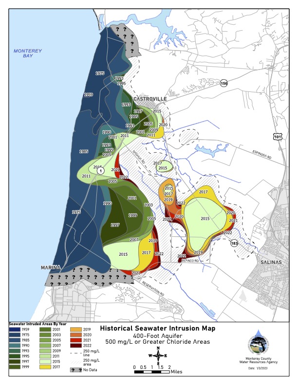
p400_2022_SWI
Pressure 400-Foot Aquifer
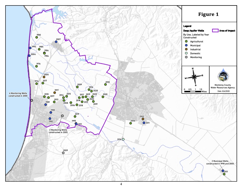
DeepWells_map
Deep Wells Map
DeepAquifers_WellsMap_August2020
Deep Aquifer Wells